Campobasso

The capital of Molise, as well as of its province, is a fascinating city on the slope of a hill between theBiferno and Fortore basins, with the Sannio and Matese mountains as a backdrop. It is not at all "at the bottom" – perhaps the root of the name could come from the word 'vassal' - and indeed its altitude of around 700 metres, amidst stepped streets and views below the rocky spur with the Castello Monforte, does not disfigure in an area that, a little further north, is populated here and there by the soaring of morges.
From a tourist point of view, in addition to the Castle and the Samnite Museum, which delves into the millennia of Molise with its artefacts, the atmosphere of the alleyways descending from the original early mediaeval village and, below, the so-called Murattian City, commissioned in the early 19th century by Joachim Murat - Napoleon's brother-in-law, and in those decades King of Naples - among wide avenues, squares and botanical gardens worthy of a garden city, are attractive. It is in the Muratti quarters that most of the public buildings and businesses are located, and it is here that people come to stroll around in the evening.
In terms of history, we start from a possibly Lombard origin to a role as county capital under the Normans, in a story of foreign dominions dramatically marked by the earthquake of 1456. Reconstructed thanks to the seigniory of the condottiere Cola Monforte, the city then saw various other seigniories alternating, until the Napoleonic era and the passage into Italy - with the whole of the former Bourbon Kingdom - after the feat of the Thousand.
Castropignano

From Campobasso, the route in search of morges could reach Castropignano via the state road 751. In doing so, however, you would miss a stop at Oratino, which stands on a limestone cliff very close to the idea of a morgia and has another isolated cliff with an impressive mediaeval tower at the top a short distance away. It is better then to choose provincial road 41, which after passing Oratino reaches the proposed intermediate destination anyway - counting on a short final diversion to state road 618.
Castropignano
also has its historic centre and Evoli Castle perched on a rocky spur. The village has its historical roots in the times of the Sannites, between the ninth and first centuries BC, when entrenchment could be very useful - even against Rome, which in the long run imposed itself - to defend against unwanted intrusions.
Another key feature of the historical environment are the tratturi, the routes for the seasonal movement of flocks according to a centuries-old custom known as transhumance.. In the Castropignano countryside, it happens that this tradition is not entirely lost. A farm on the road to Torella del Sannio, in city ward Selva 42 to be precise, practised transhumance until recently through the Castropignano countryside along the sheep-track between Castel di Sangro and Lucera. Today, their herds only move to the neighbouring hills in the Biferno valley, but they still make some pretty good cheeses.
Pietracupa

From Castropignano to Pietracupa – via Fossalto, along the state road 747, which is appropriately named Fossaltina - is more or less twenty kilometres. When one arrives, one is confronted with the confirmation that not all morgues are isolated in the green countryside, as is the case elsewhere. Pietracupa has its own morgia that seems like a cradle for the town: a reassuring native mass that the houses, the uphill ramps and the parish church of St Anthony seem to embrace and, at the same time, support. As elsewhere, this bog is a large 'dark' stone, but not a threat. There is also an information centre of the Cenozoic Morge Park of Molise in the village.
In the area between Castropignano and Pietracupa lies - off the beaten track, but worth at least mentioning - Torella del Sannio, with a castle atop its hill that looks like something out of a treatise on mediaeval military architecture.
Bagnoli del Trigno

Even in Bagnoli - "del Trigno" so as not to confuse here with Irpinia and Naples - the settlement has a morgia as its centre of gravity. This is immediately apparent after driving about ten kilometres from Pietracupa following the axis of provincial road 74.
The Sanfelice Castle dominates everything from the top of a more massive cliff, but the bell tower that almost acts as a signal tower to the church of S. Silvestro and the entire village uses one of those limestone spurs that the itinerary is gradually tracing. As in Pietracupa, the geological phenomenon and the community's aspiration for heaven have historically helped each other.
A cliff so high above the village as the one in Bagnoli does not easily lend itself to acting as a climbing wall, a function that is put into practice in other cases. Not here but further into the heart of Sannio, not far from Frosolone, a pretty TCI Orange Flag village, the Morgia Quadra offers inviting walls for climbing and free climbing. The nature between Frosolone and Sessano is decidedly more mountainous than in the middle Trigno valley, with conifers, beech forests, wide pastures, small lakes, jumps useful for paragliders or hang-gliders, and underground a world of caves.
Pietrabbondante

Here - more than 1,000 metres above sea level, and about 20 kilometres from Bagnoli del Trigno along the state road 650 - the greatest tourist-cultural attraction is undoubtedly the Italic Sanctuary near the village: a majestic archaeological site more than enough to make Pietrabbondante a must-see destination. It is also true, however, that nestling the settlement are three spectacular morges, not to be overlooked even by antiquity buffs.
One of them, the so-called Castello, has the mother church of Santa Maria Assunta at its base, while another morgia is called 'dei Marchesani' after the name of a family that was historically dominant in the village, and the third is called 'dei Corvi' because it is said to make or used to make their nests. Paths created on the rock face encourage climbing up to the Castle and the Morgia dei Marchesani, to enjoy the wide panorama and perfect silence.
The name of the village, however, derives not from the abundance of morge but from the abundance of stone in the Italic Sanctuary, which remains a site of primary importance in approaching the civilisation of the Samnites.
Trivento

There are no morges surrounding the ups and downs and steps of Trivento, at an altitude of almost 900 metres, but here is the headquarters of the Park of the Cenozoic Morge of Molise, the institution that has been promoting the geological phenomenon since 2015 and bringing together the municipalities concerned. Leaving Pietrabbondante, it is about thirty kilometres to Trivento, along the state roads 650 Fondo Valle Trigno and 747 Fossaltina. As in Pietrabbondante for the Italic Sanctuary, the name Trivento has Samnite origins, while the environment cannot go back that far in time and rather recalls the Middle Ages. The Cathedral and the Badia di S. Maria di Canneto date back to that time.
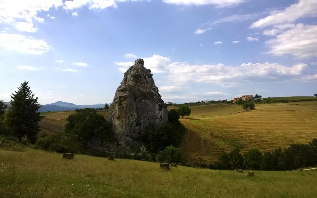
However, we return to the morgia when we lose altitude from Trivento towards Limosano to encounter in the Salcito area probably the most emblematic morgia - today we would say the most iconic, isolated as it is in the countryside - in the Pietravallelocality. But Limosano also has a morgia.
Between Trivento and Limosano, along the provincial road 73a, Sant'Angelo Limosano is located on the watershed between the Biferno and Trigno basins, offering a vast panorama ranging from the Frentani and Sannio mountains to the Matese, the Frosolone mountains, the Mainarde, the Maiella and the Adriatic to the Tremiti islands. Nor can it be forgotten that Sant'Angelo is the birthplace of Pietro Angelerio, later Pope Celestine V, who went down in history for his 'grand refusal' of the papacy in 1294. In the lands of the morge, in short, there is also Great History.
Ripalimosani

On the way back to Campobasso, the route passes through Ripalimosani, practically halfway between Limosano and the provincial capital. Here, too, there are no bogs - you are now outside the typical area - but in any case a feast of ups and downs in the shadow of a bell tower: that of S. Maria Assunta. The altitude has decreased, and is now just over 640 metres above sea level.
Next to the parish church, dedicated to Our Lady of the Assumption, is the Castle, also known as the Ducal (or Marchesale) Palace and today used as a hotel. But among the reasons inviting one to stop by, there are above all two appeals of a historical-religious nature: the Convent of St. Peter Celestine, named after the Pope of the 'great refusal' who was later sanctified, and a copy of the Holy Shroud - one of only three in the world - made by the Savoy family at the end of the 16th century in contact with the original, which they donated to the Spanish sovereign who then ruled over southern Italy, and now kept here at the parish church.
More secular is the local dedication to mandolins, for which strings were manufactured in the village until recently. A Mandolin School and its Music Circle named after Pietro Mascagni are still in full operation: it would be good to check if a concert is planned when passing through Ripalimosani, because that would be a surprise.


